Trump’s latest map expands U.S. territory across North America and beyond
 13 oC
13 oC 
Güneşli

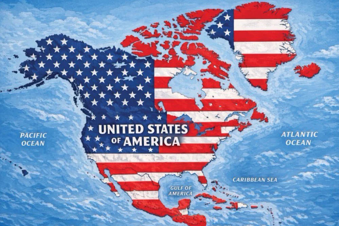
U.S. President Donald Trump has posted a map depicting the American flag covering much of North America, as well as Greenland, Iceland and several Caribbean islands, renewing attention around his repeated calls for expanding U.S. territorial influence beyond the country’s existing borders.
Trump shared the map on Truth Social on Monday morning. The image showed the pattern of the U.S. flag superimposed across the United States, Canada, Mexico and parts of Central America, as well as Greenland, Iceland and several Caribbean islands, including Cuba and Jamaica.
The post comes after Trump has repeatedly expressed interest in acquiring or taking control of territory outside the United States, most notably Canada, Greenland and the Panama Canal.
While Trump’s previous territorial ambitions have focused primarily on Canada and Greenland, the inclusion of Mexico and Caribbean nations in the latest map represents a broader depiction of the territory associated with the United States.
The post also comes amid renewed tensions between Washington and Ottawa over trade. The United States and Canada have imposed tariffs on one another’s goods, adding friction to relations between the two neighboring countries.
Against that backdrop, Trump recently signed an executive order seeking to rename Lake Ontario, which shares its name with the Canadian province of Ontario, as “Lake America.”
The latest map follows another unusual post by Trump on Sunday involving the state of New Mexico.
Trump shared an image labeling New Mexico as “New America” after an online hoax circulated claiming that he had signed an executive order changing the state’s name.
The image showed a large “X” placed over the word “Mexico” in the state’s name, with the word “America” appearing underneath.
The White House’s official account subsequently shared the same image on X.
Trump’s latest posts have drawn renewed attention to his views on U.S. territorial expansion and his willingness to use provocative maps and imagery to communicate his political messages.
His previous proposals involving Canada, Greenland and the Panama Canal have already generated controversy internationally, while the latest imagery appears to broaden the geographic scope of his territorial rhetoric.
The posts come at a time when the Trump administration is also facing significant diplomatic and economic tensions with neighboring countries, particularly Canada and Mexico, making the imagery especially sensitive across North America. (ILKHA)
LEGAL WARNING: All rights of the published news, photos and videos are reserved by İlke Haber Ajansı Basın Yayın San. Trade A.Ş. Under no circumstances can all or part of the news, photos and videos be used without a written contract or subscription.
Gaza’s Government Media Office (GMO) has rejected Israeli claims that the besieged territory is experiencing an abundance of food, saying images showing the destruction of spoiled products are being deliberately misused to conceal the devastating humanitarian reality facing Palestinians across the Gaza Strip.
At least two people were killed and 10 others injured after Russia launched a massive overnight barrage of missiles and drones against Kyiv and surrounding areas on Tuesday, setting buildings ablaze and sending thick clouds of smoke over the Ukrainian capital.

Pro-Palestine activists took to the streets in Denmark in a powerful show of solidarity with Gaza, demanding an end to Israel’s attacks and freedom for Palestinian prisoners held in Israeli prisons and detention centers.
A 29-year-old Palestinian man was killed by Israeli forces’ gunfire on Tuesday during a military raid on the town of Aqaba, south of Nablus in the occupied West Bank, Palestinian security sources said.